GDC2018:谷歌开放了 “GOOGLE MPA” API接口

文 ROAD
译 haloVR
在GDC 2018的Google Developer Day演讲中,产品经理Clementine Jacoby和Google地图的负责人Patrick Donelan介绍了他们的技术和数据为游戏开发人员带来的进展。今年,一些使用谷歌地图API和ARCore “基于位置的”AR游戏将进入移动设备。
手动完成构建大型虚拟世界将耗费大量时间。以Rockstar游戏的“ 侠盗猎车手IV”(2008年)为例,它仍然是有史以来创造的最昂贵和最富有的游戏世界之一,Jacoby指出,这款游戏在发布时只有曼哈顿市中心(在真实世界范围内)。Google现在提供了一条更简单的路线,即使是小团队也可以通过Google Maps API利用丰富的地理数据。
该团队已经建立了一个SDK,将该技术引入到Unity中,“完成所有繁重任务”并且“不需要Google Maps专业技能”即可开始使用,并帮助开发人员设计真实世界的互动环境,这带来了一系列独特的挑战。

“做得好,需要了解玩家的直接环境以及他们的大背景,”Jacoby说。“我们帮助你在真实世界的地点设计游戏玩法,这样你就可以选择适合,独特和有趣的地点,无论你的玩家在哪里。”
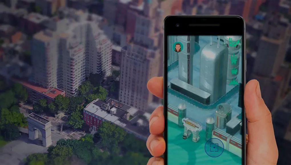
Donelan展示了Unity集成如何轻松地将Google Maps构建和对象数据的平滑,无纹理几何转换为使用光照和纹理的游戏体验的风格化设置,甚至可以改变建筑物的高度。然后,使用Playable Locations API,您可以创建具有任务的游戏并在重要位置生成点,并在世界任何地方运行。Donelan表示:“我们使用大量Google地图信号来确定游戏和AR体验的最佳位置,这些体验以突出性和流行度排名。“您可以按照您的游戏需要的任何密度申请积分,并微调这些积分的分配方式。”
还有其他功能可以为环境提供更丰富的细节,例如用于向建筑物添加自定义大小的纹理的“九切片”,用于向屋顶添加额外几何体的装饰器以及用于模拟环境遮挡的道路和建筑物周围的边框。SDK还集成了Unity的实时照明和物理系统。
Donelan随后重点介绍了一些由开发人员在几周内使用程序规则和模块化资产包创建的精心打造的示例。首先,我们展示了两种城市环境的风格化视图,以令人印象深刻的细节放大到街道层面,Google地图数据以有机方式通知程序化渲染。在最后一个例子中,显示了蒙大拿州冰川国家公园的广阔区域,使用谷歌地图高程数据以及程序生成的岩石和植被在Unity中进行渲染,显示SDK不限于城市环境。
总体信息:使用Google地图地理数据轻松构建全球范围内丰富的游戏体验,使用适用于真实世界的游戏玩法,并将玩家推向热门场所,或根据游戏风格将游戏推向流行的地方。最后,2018年使用ARCore和Google Maps API推出了三款游戏:《侏罗纪世界》、《捉鬼敢死队》和《行尸走肉:我们的世界》。
此文由haloVR发布 2018 03 21

Google Opens ‘Maps’ API So Devs Can Create ‘Pokémon Go’-style Games
During the Google Developer Day presentation at GDC 2018, Product Manager Clementine Jacoby and Engineering Lead Patrick Donelan at Google Maps presented the team’s progress in bringing their technology and data to game developers. Several ‘location-based’ AR games using Google Maps APIs and ARCore are coming to mobile devices this year.
Building large virtual worlds is costly and time-consuming when done by hand. Using the example of Rockstar Games’ Grand Theft Auto IV (2008), which remains one of the most expensive and richest game worlds ever created, Jacoby noted that this was, at launch, it only as big as downtown Manhattan (in terms of real-world scale). Google is now offering an easier route, where even small teams can leverage vast, rich geodata through Google Maps APIs.
The team has built an SDK to bring the technology to Unity which “does all the heavy lifting” with “no Google Maps expertise needed to get started,” and helps developers design interactions around real-world places, which presents a unique set of challenges.

“Doing it well requires knowing a lot about the player’s immediate environment and also their larger context,” says Jacoby. “We help you design gameplay around real-world locations so you can choose places that are appropriate, unique, and fun to play, no matter where your players are.”
Donelan demonstrated how the Unity integration can easily turn the bland, untextured geometry of Google Maps building and object data into stylised settings for game experiences using lighting and textures, or even changing the height of the buildings. Then, using the Playable Locations API, you can create a game with missions and spawn points at prominent locations, and have it work anywhere around the world. “We use a vast array of Google Maps signals to determine the best places for gameplay and AR experiences ranked by prominence and popularity,” says Donelan. “You can request points at whatever density your game requires, and fine-tune the way those points are distributed.”
There are additional features to enable richer detail to the environment, such as ‘nine slicing’ for adding custom-sized textures to buildings, decorators to add extra geometry to rooftops, and borders around roads and buildings to simulate ambient occlusion. The SDK also integrates with Unity’s real-time lighting and physics systems.
Donelan then highlighted some well-polished examples created by a single developer in just a few weeks using procedural rules and modular asset packs. Firstly, two stylised views of city environments were shown, zooming down to street level at an impressive level of detail, with Google Maps data informing the procedural rendering in an organic way. In the final example, a vast area of Glacier National Park in Montana was shown, rendered in Unity using Google Maps elevation data, with procedurally generated rocks and vegetation, showing the SDK is not limited to urban environments.
The overall message: it’s easy to harness Google Maps geodata to build rich game experiences that work on a global scale, using gameplay suitable for the real world, and driving players to popular places, or off the beaten path, depending on the style of game. Finally, three games coming in 2018 using ARCore and Google Maps APIs were featured: Jurassic World Alive, Ghostbusters World, and The Walking Dead: Our World.
UP TO haloVR 2018 03 21

最新活动更多
-
7.30-8.1火热报名中>> 全数会2025(第六届)机器人及智能工厂展
-
精彩回顾立即查看>> 【线下论坛】新唐科技2025新品发布会
-
精彩回顾立即查看>> 【在线直播】解密行业检测流量密码——电子与半导体行业
-
精彩回顾立即查看>> 【深圳 IEAE】2025 消费新场景创新与实践论坛
-
精彩回顾立即查看>> 【限时免费】安森美:Treo 平台带来出色的精密模拟
-
精彩回顾立即查看>> 【在线会议】ImSym 开启全流程成像仿真时代
推荐专题


 分享
分享


发表评论
请输入评论内容...
请输入评论/评论长度6~500个字
暂无评论
暂无评论